By CAPT Mark Poster, CMI
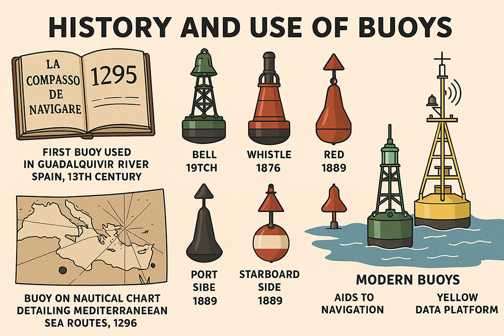
Every mariner needs to be aware of the various buoyage systems in your area of operation, and just as importantly, to obtain whatever local information, such as laws and hazards, that may be helpful for a safe day on the water. Buoys have been around for a long time. The first buoys were used in the Guadalquivir River in Spain in the 13th century, according to the 1295 mariners’ handbook, La Compasso de Navigare. A buoy was recorded on the nautical chart detailing Mediterranean Sea routes in 1296. In the 19th century attempts were made to provide a better nighttime presence, so bells were added to clang from the wave actions, and in 1876, a Patented whistle was added. In 1889, some countries agreed to mark the port side of channels with black buoys and the starboard side with red buoys. The International Association of Lighthouse Authority (IALA) Maritime Buoyage System was developed in response to a disaster in the Dover Strait in 1971.
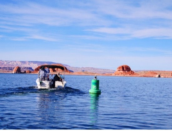
Three different types of buoys are used for Aids to Navigation (ATONS), mooring and yellow data platforms collecting meteorological and oceanographic information. They can be the “road signs” of the waterways, hazard markers, regulatory, information, mooring buoys and data platforms. Modern buoys may be equipped with lights, retro-reflective tape, radar reflectors, and fog signals and can have electric lights that range from a few hundred to 1,000 candelas. Buoys can also have bells, whistles, gongs, horns, and air sirens. Buoys will be able to gather and analyze data on a variety of topics, including weather, ocean currents, water quality, and marine animal activities.
Buoys have come a long way, but the mariner must be wary; buoys may not be permanently attached, and even if they are, Mother Nature has a way to let us know who’s Boss. Missing and off-station buoys can have dire consequences. Current chart information is critical for a safe voyage, especially if one is relying on the presumption that a buoy’s position is fail-safe. Annual, seasonal and daily water level fluctuations are often the culprit. And they never stop.
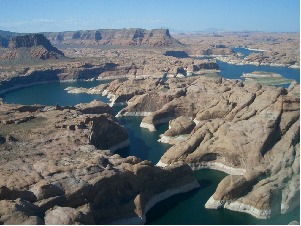
Lake Powell has nearly 2,000 miles of shoreline, more than all the western continental states’ shoreline on the Pacific Ocean. Glen Canyon Dam was completed in 1963, creating the 186-mile length lake. Water levels fluctuate constantly, creating a challenge in maintaining the ATONS.
It’s important to note that a comprehensive, yearly breakdown of boat accidents on Lake Powell, including the number of incidents, injuries, and fatalities, is not readily available in a single source. Between 1959 and 2005 Lake Powell saw 351 fatal accidents resulting in 386 fatalities, with an average of 8.4 fatalities per year. From 2005-2012: Powell had 25 fatalities, 3rd highest in Sector San Diego AOR (after Mead/Havasu), 425 accidents (2nd to Mead).
During my research of an injury-producing accident case on Lake Powell, a great amount of material was reviewed, including ATON specific and Lake Powell specific documents and reports. One was “Waterway Analysis Report, Lake Powell ATON/PATON Overview, April 2017 by: USCG Sector San Diego Waterways Management Division and Coast Guard Auxiliary”. A pretty long title even for a government publication.
Highly qualified USCG Auxiliarists that are trained to be “ATON Verifiers” for the “Aids to Navigation and Chart Updating (AtoN/CU) Program” are tasked with the job of inspecting every buoy in an assigned area. They are checked for location, being in sequence, properly operating and functional lights, retro-reflective tape, sound signal, etc. The result of their findings is included in this document and is a legal record. The following are excerpts from this report.
ATON Maintenance
”National Park Service (NPS) is required by the Memorandum of Understanding (MOU) with USCG to maintain federal aids to navigation. Two ATON boats (46’ at Bullfrog & smaller boat at Wahweap) are used to maintain the buoys, although they don’t go up lake as much (inferred); hard to keep up with lake level fluctuations.
The NPS ATON crew does not come up to Bullfrog very often therefore buoys are often off.
The other issue may just be unfixable due to lack of personnel, budget for NPS.
They, of course, also have other duties assigned to them which means they cannot keep up with moving the main channel markers as the lake levels fluctuate. This leads to lots of main channel markers getting loose and way off station, especially the farther you go up lake from Wahweap.”
Condition of ATON System
“NPS does not recommend that boat operators attempt to navigate vessels before official sunrise or after sunset. Operators who choose to operate at night subject themselves, fellow passengers and other boaters to accidents which can result in property damage, serious injury or death.
The boating public is regularly confusing these with no wake markers and as they are scattered around like birdshot out of a shotgun it is frustrating for waterway users.
Buoys at Bullfrog scattered like buck shot; confusing boating public; extending out into main channel/not lit or marked. Confusing day or night.
NPS ATON office concerns: improper use of lateral and regulatory markers; entrance buoys; lit inconsistently.
All hazards, known and emergent should be marked; even if temporary (liability).
Poorly maintained nav aids becomes a liability.
Discrepancies
- Inoperable lights: 9
- Lights were weak: 6
- No markings: 2
- Buoys located too close to shore or very near hazards that navigating at night dangerous: 6
- Additionally: There are 3 buoys marked #26
- There are 2 buoys marked 22A
- The buoys between 22A and 23D are not in numerical order.
- There are 2 buoys marked 22B in this same area.
- Buoy 28A needs to be repainted or replaced as most of the paint is gone.
- There are no buoys between buoy 59 and buoy 62, making navigation difficult.
- Buoy 36 is not lit and had no reflective tape.
- Buoys not lit, but had reflective tape: 14. (Checked during daytime)
Antelope Point Marina, Dangling Rope Marina Wahweap Marina
- Non-operable lights: 12.
- No red and green harbor entrance lights.
- Red harbor entrance light is laying sideways on shore.
- Buoys need reflective tape, paint,
- Buoys are missing: 6.
- Buoys are off station: 10.”
Based on the information provided in this comprehensive report, which demonstrates a complete failure to maintain the system as required by the MOU, the NPS has exposed itself to liability.
But on the other hand…
From: “U.S.C.G. Auxiliary Aids to Navigation/Chart Updating Study Guide”, Eleventh District Southern Region 2011
“Mariners must not rely on buoys alone for determining their position due to factors limiting buoy reliability. Buoy positions represented on nautical charts are approximate positions only, due to the practical limitations of positioning and maintaining buoys and their sinkers in precise geographical locations. Buoy moorings vary in length. The mooring lengths define a “watch circle”, and buoys can be expected to move within this circle. Actual watch circles do not coincide with the symbols representing them on charts. Buoy positions are normally verified during periodic maintenance visits. Between visits, environmental conditions, including atmospheric and sea conditions, seabed slope and composition, may shift buoys off their charted positions. Also buoys may be dragged off station, sunk or capsized by a collision with a vessel.”
Two objects attempt to occupy the same space at the same time.
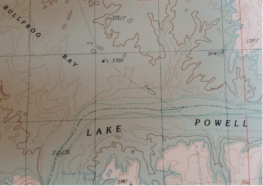
Between Bullfrog Landing and Hall’s Crossing, directly under the ferry boat course, there is an island that, depending on lake levels, may be completely submerged to a safe depth, or hidden just below the surface, or just barely above the surface, or creating a growing island. Since the Dam was completed in 1963, there have been several years when, depending on lake levels, this island has been a known hazard. It is marked on the charts. Due to the high traffic in this area between two marinas and the ferry boats, and the fact that it is a known hazard at certain water levels, it should be pre-emptively marked when those levels are such that it becomes dangerous to boating activities.
On a summer evening while returning to Bullfrog Bay from the north, a boat hit this submerged island resulting in catastrophic injuries. Our team made three trips for inspections. We planned to visit the island at the same water level as on the night of the incident. The island was about 1.5 feet above lake level as can be seen in the photograph below. The island was submerged by several feet on the second visit.
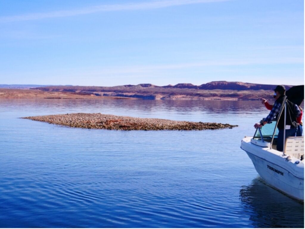
Research of historical records indicate that between 1963 when the dam was built and 2017 there were 14 (of the 54) years that the island was between 5 feet below the surface and 1.5 feet above the surface, where it would be a hazard. This island was not a surprise to the agencies; it was a known hazard and should have been marked.
This is where the previously mentioned local knowledge would have been helpful, as well as an effective buoy maintenance and monitoring system. Budgets and personnel notwithstanding, it is a shame that our “road signs on the waterways” are in such a sad state of disrepair on Lake Powell.
Buoys are not bad, in fact, most are good. Nothing beats local knowledge and the wisdom to know that everything relied upon for navigation must be confirmed or at least suspect until confirmation has been obtained. How many Skippers are aware that the lake’s entire ATON system is in such disarray. The bottom line is the Skipper is always responsible for everything that happens onboard. But courts may appropriate some of the fault to others for contributing to the incident. Even agencies can be held accountable for failing to maintain ATONs if it can be demonstrated that failure contributed to an accident.
#Buoyage systems #Aids to Navigation #IALA Maritime Buoyage System #Nautical charts #Boating safety